What Makes Newark a Hotspot?

Newark is facing the impacts of climate change and sea level rise with billions of dollars in assets at risk as well as severe impacts to human lives and livelihoods if no action is taken. Currently, its shoreline resilience is threatened by proposed developments that will pave over critical habitat for endangered species and place thousands of residents in a FEMA flood zone—requiring immediate protection.

Quick Data

TOTAL Population: 47,815

Population by Race

Cost Burdened Renters

Key Information

TIME IMMEMORIAL

Ohlone shellmounds suggest Ohlone presence as far back as 4000 BC. The Ohlone tribes utilized the natural resources of the surrounding marshlands, forests, and hills.

1856

The region known as Newark was colonized and named after Newark Castle in Scotland.

1876

The Southern Pacific Railroad arrived in the area, leading to increased transportation and trade opportunities.

1955

Newark was officially incorporated as a city in response to an effort to incorporate it into Fremont. During this time, Newark experienced a period of growth and development, with the expansion of residential and industrial development.

1958

The Nimitz freeway opened and connected Newark with major job centers. 

1960–1970

A population boom occurred, adding nearly 30,000 residents within 10 years. 

1876

The railroad from Santa Cruz to Newark was completed, spurring a development boom.

2010

Newark launched their Climate Action Plan Initial Framework, which included:

  • Adaptation Action 8.1: Conduct a Vulnerability Assessment
  • Adaptation Action 8.2: Develop a Strategic Plan of Climate Change Adaptation
2013 & 2017

The City’s General Plan was completed in 2013 and the Parks Master Plan in 2017. The Master Plan included:

  • Goal PR-5 to “Improve Newark’s trail system, with a focus on access to the Newark shoreline and access between the shoreline and Newark neighborhoods”
  • Cedar Boulevard Linear Park to connect communities to the bayshore
NOVEMBER 14, 2019

The Newark City Council voted 4 to 1 to approve the proposed “Sanctuary West” development. Greenbelt Alliance, The Citizens Committee to Complete the Refuge, and Newark residents and allies have vehemently opposed the development of Area 4, successfully winning two lawsuits to force additional environmental review, and challenging every aspect of the development. The final decision was challenged by a lawsuit by the Citizens Committee to Complete the Refuge and the Center for Biological Diversity; the court ruled in favor of the development, moving the project forward. The Citizens Committee to Complete the Refuge, Greenbelt Alliance, and many partners continue to work hard to oppose the development and seek to permanently protect Newark Area 4 before it’s too late.

Climate Vulnerabilities

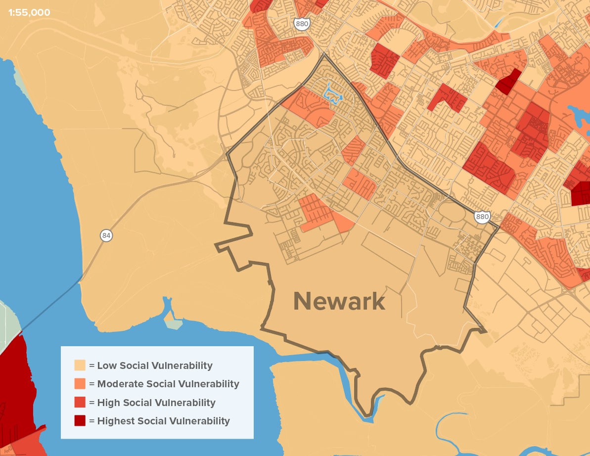
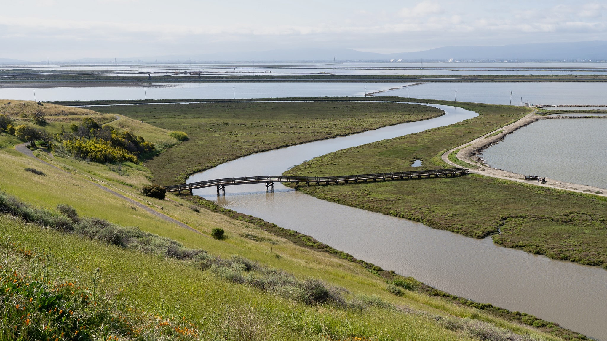
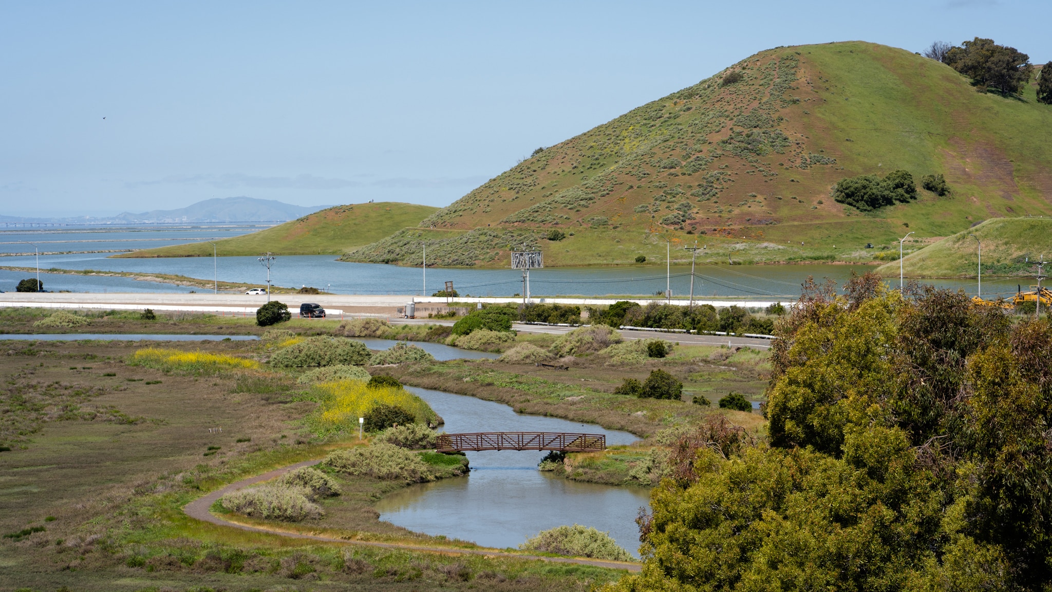
Newark faces a multitude of water-related climate risks. As sea levels rise over time, flood risk will increase along the shoreline, but shallow groundwater will also cause flooding in inland areas as rising seas push the groundwater all the way to the surface, resulting in flooding, unstable infrastructure, and building instability. Newark has some of the only undeveloped, unprotected wetlands in the Bay, and if swift climate action is taken, these wetlands and other nature-based solutions can provide protection against impending flood risk.
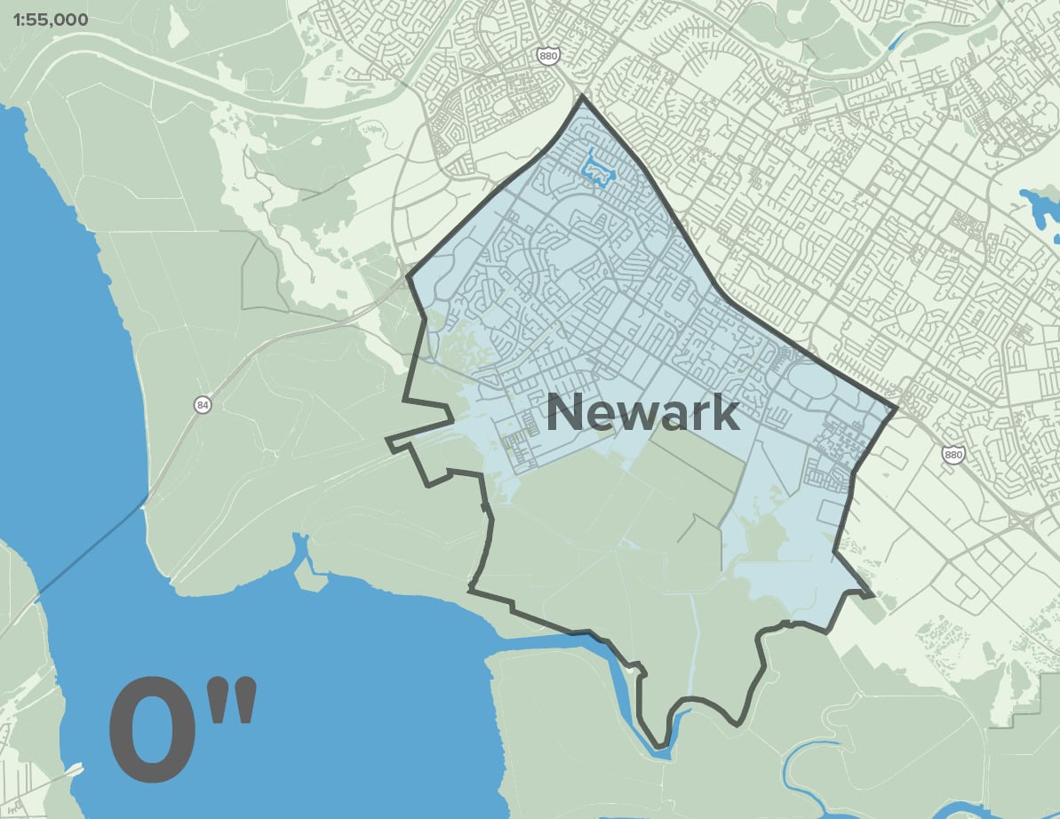
Sea Level Rise

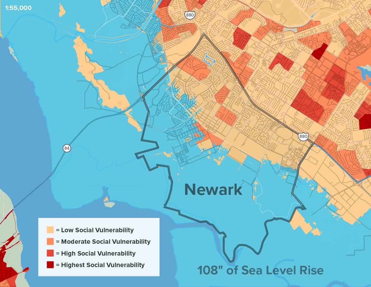
In 50 years, with 66 inches of sea level rise, exacerbated by a 100-year storm, a large portion of the City of Newark—including shoreline industrial uses, the Union Pacific Railway, and the existing wetlands—are likely to be inundated with water.

Sea Level Rise
0
108

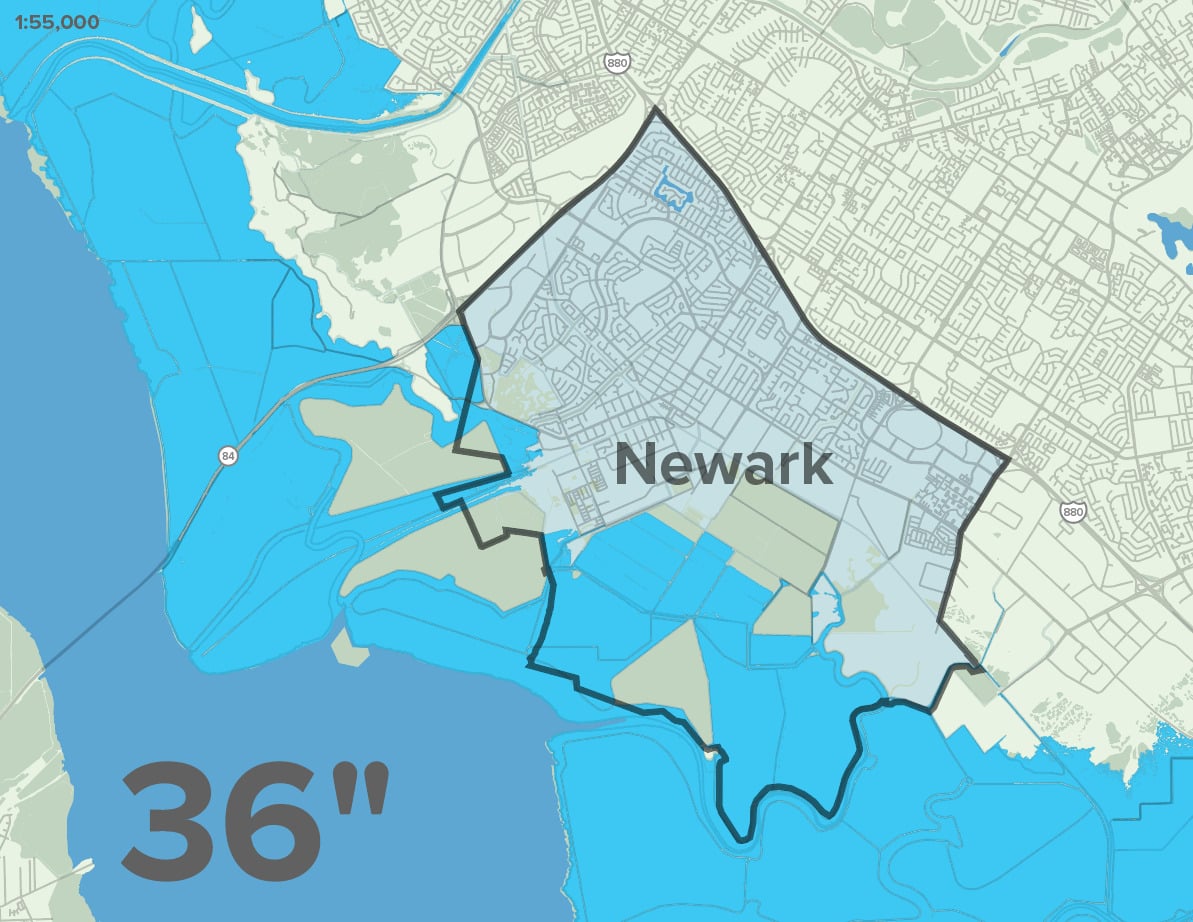
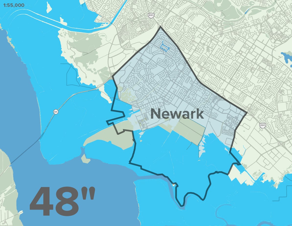
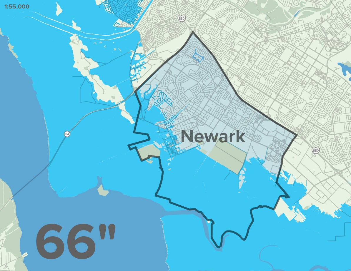
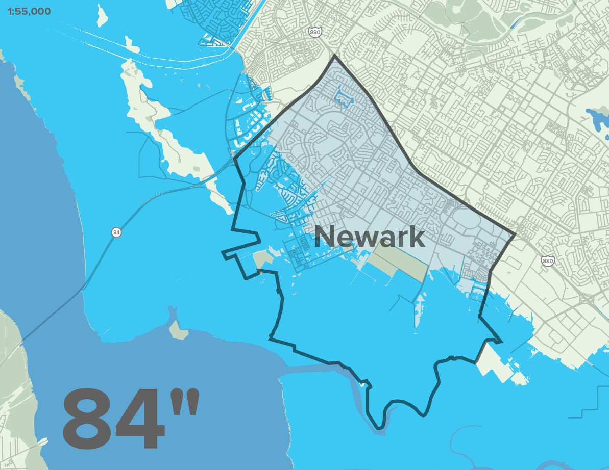
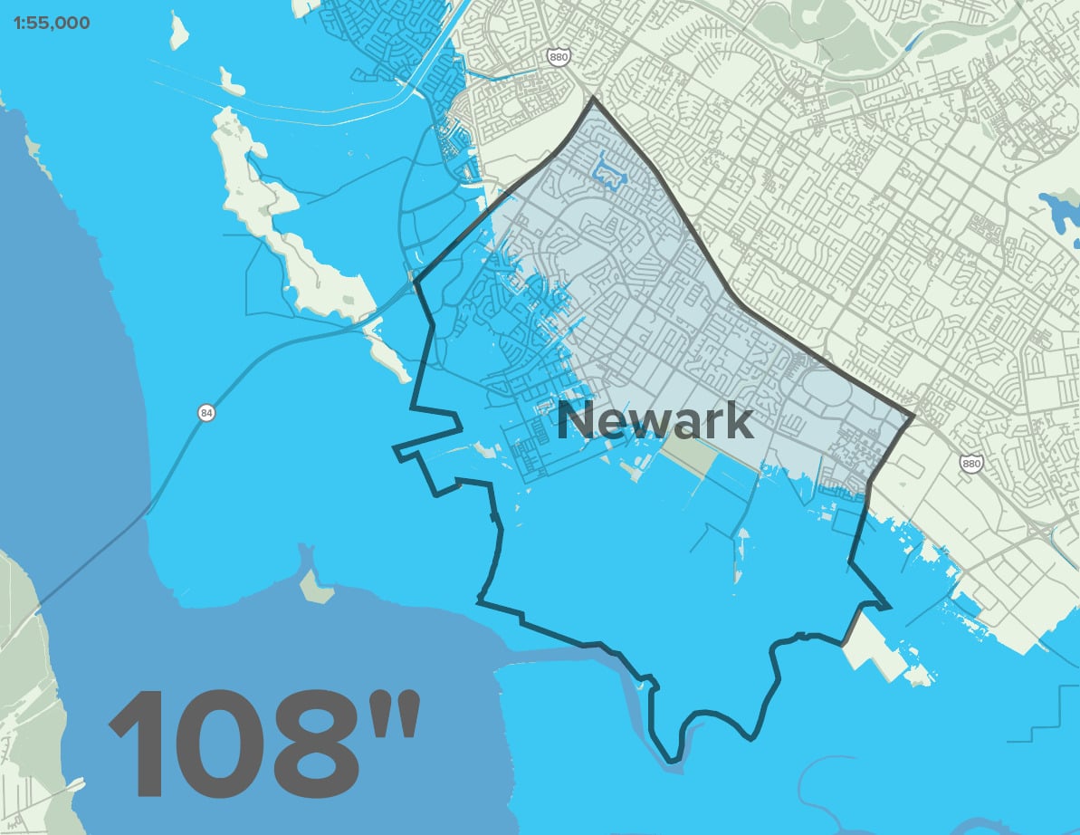
Newark is bordered by a remarkable ecosystem of wetlands and coastal habitat that is currently protecting existing development and assets from flooding. However, 88 inches of sea level rise, likely by 2100, will impact approximately 3,700 parcels and put homes and businesses at risk if no action is taken. Furthermore, Newark’s existing shoreline protection is provided by railroad tracks that serve to connect the region—transporting goods and people. This vital infrastructure will be impacted with just 36 inches of water rise. The flooding of these industrial areas will not only impact the city’s and region’s jobs and economy, but will also expose and deploy soil contaminants into the water system.

Citation:

Adapting to Rising Tides: Bay Convervationn and Development Commission (BCDC). 2020. “ART Bay Area Sea Level Rise and Shoreline Analysis Maps.” Accessed June 2, 2023. https://explorer.adaptingtorisingtides.org/download

Shallow Groundwater

Newark’s shallow groundwater table will cause flooding disruptions far sooner than sea level rise alone. With just 12 inches of water, which is expected in the next 10 years, residential and industrial lands will experience rising water levels, permanent flood conditions, impacts to underground infrastructure, and increased liquefaction risk
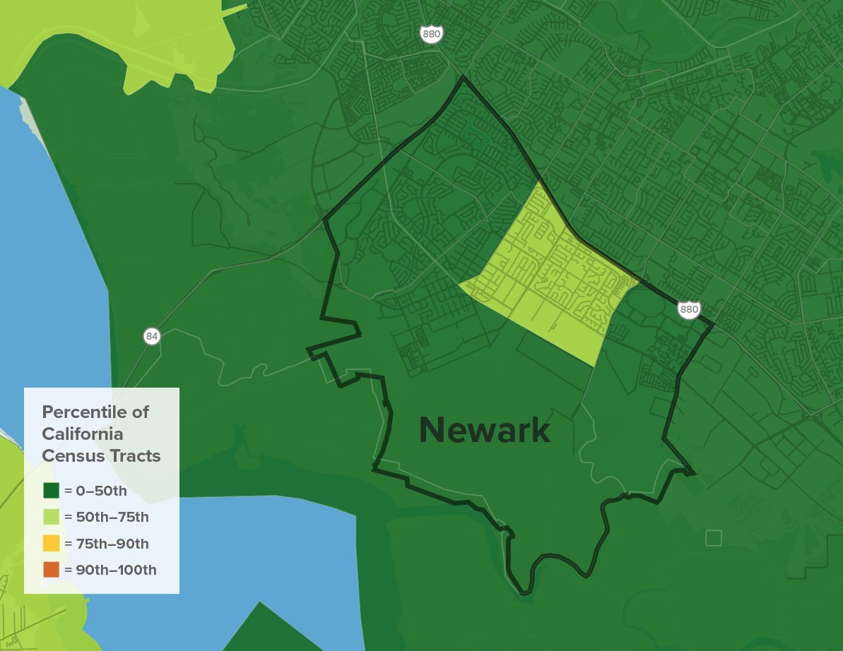
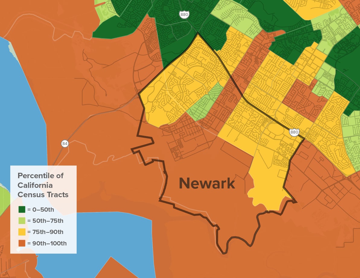
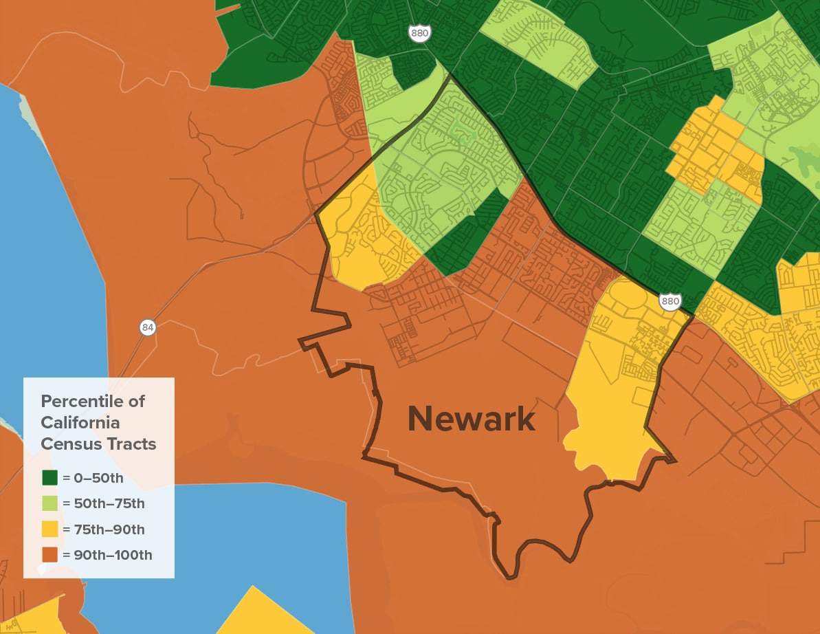
Groundwater Threat
0
108

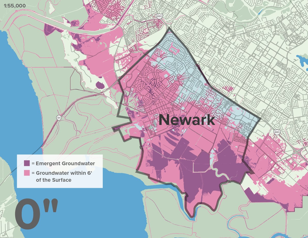
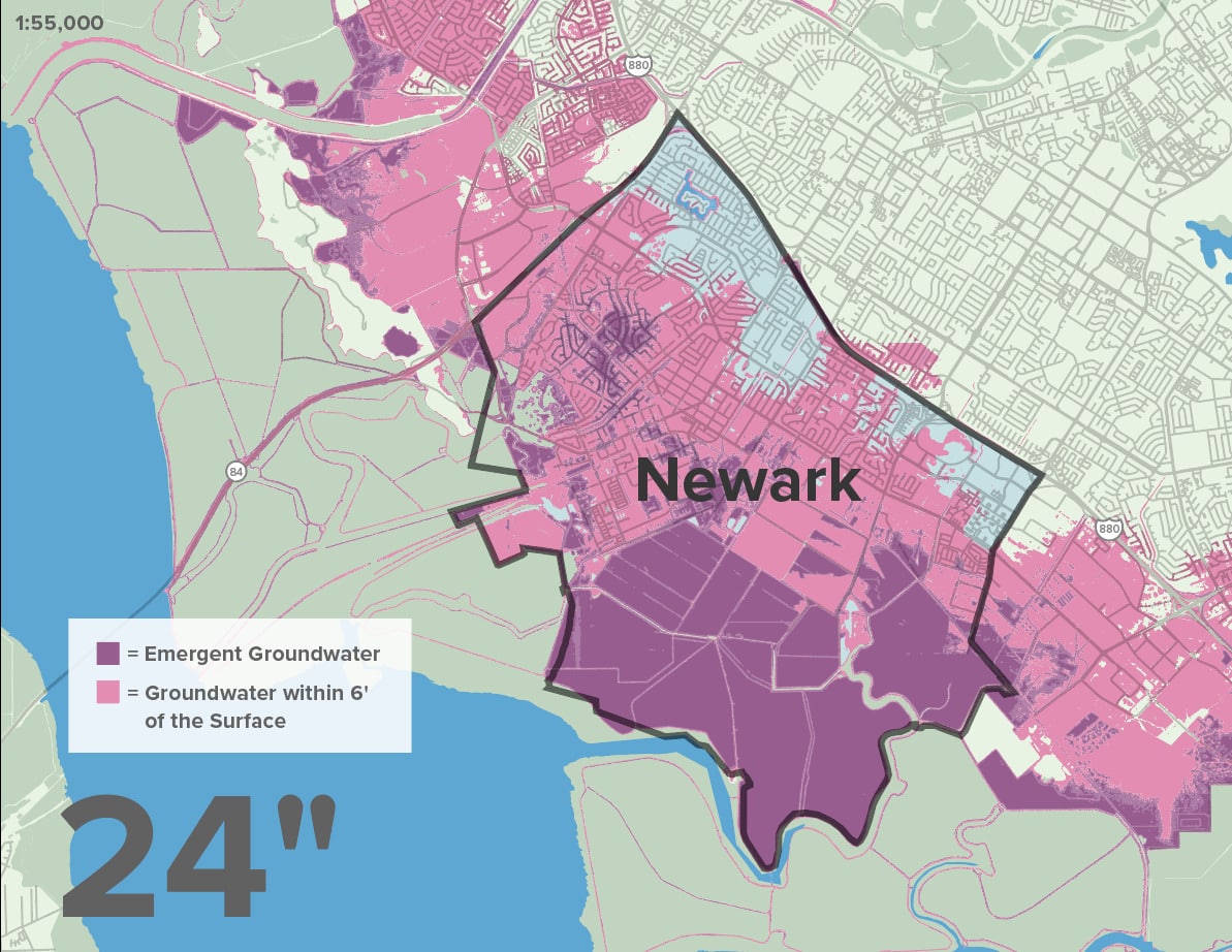
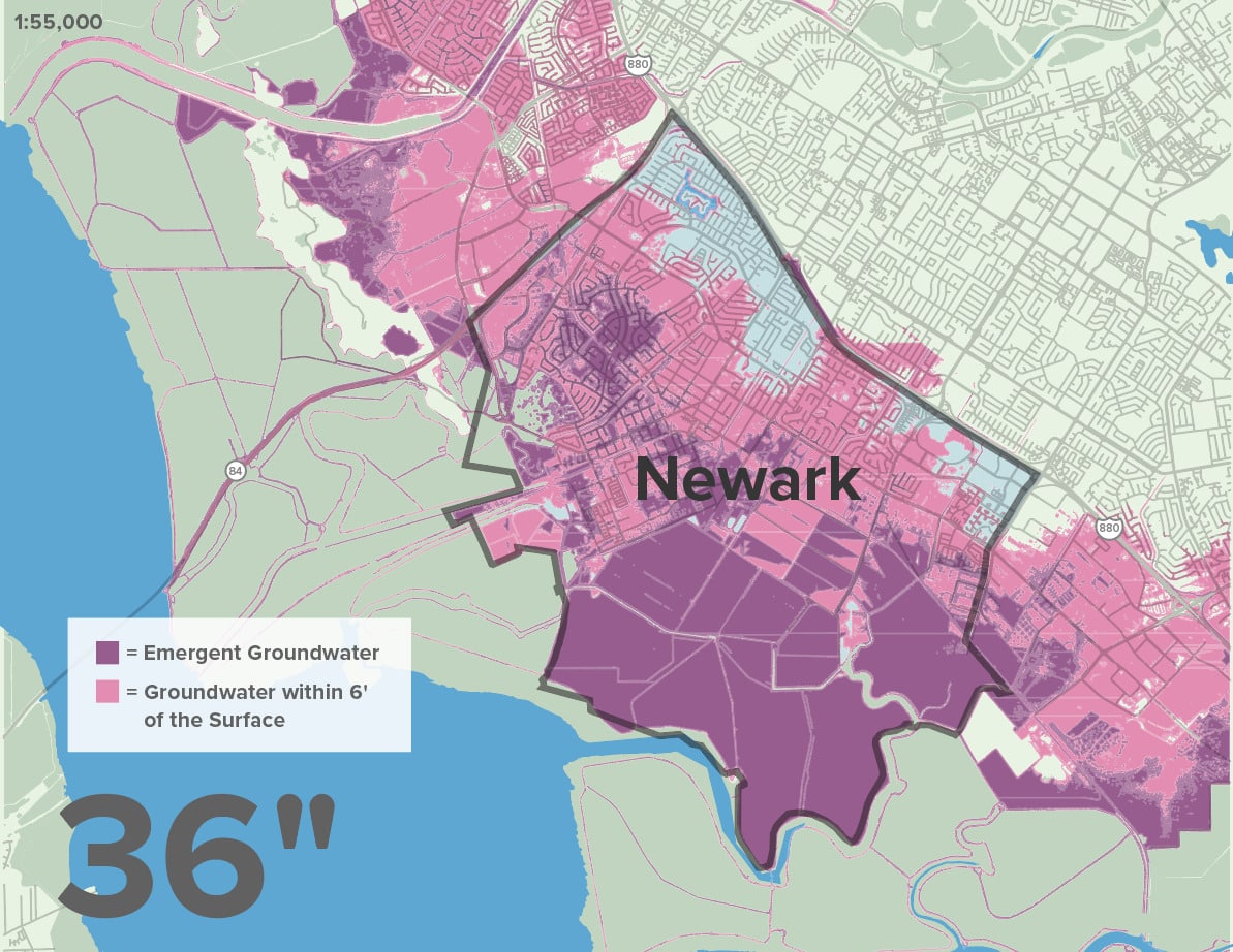
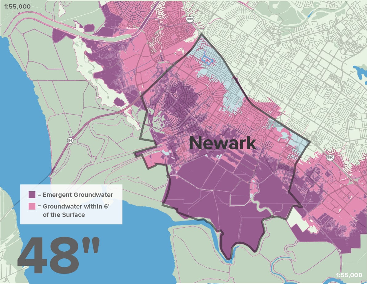
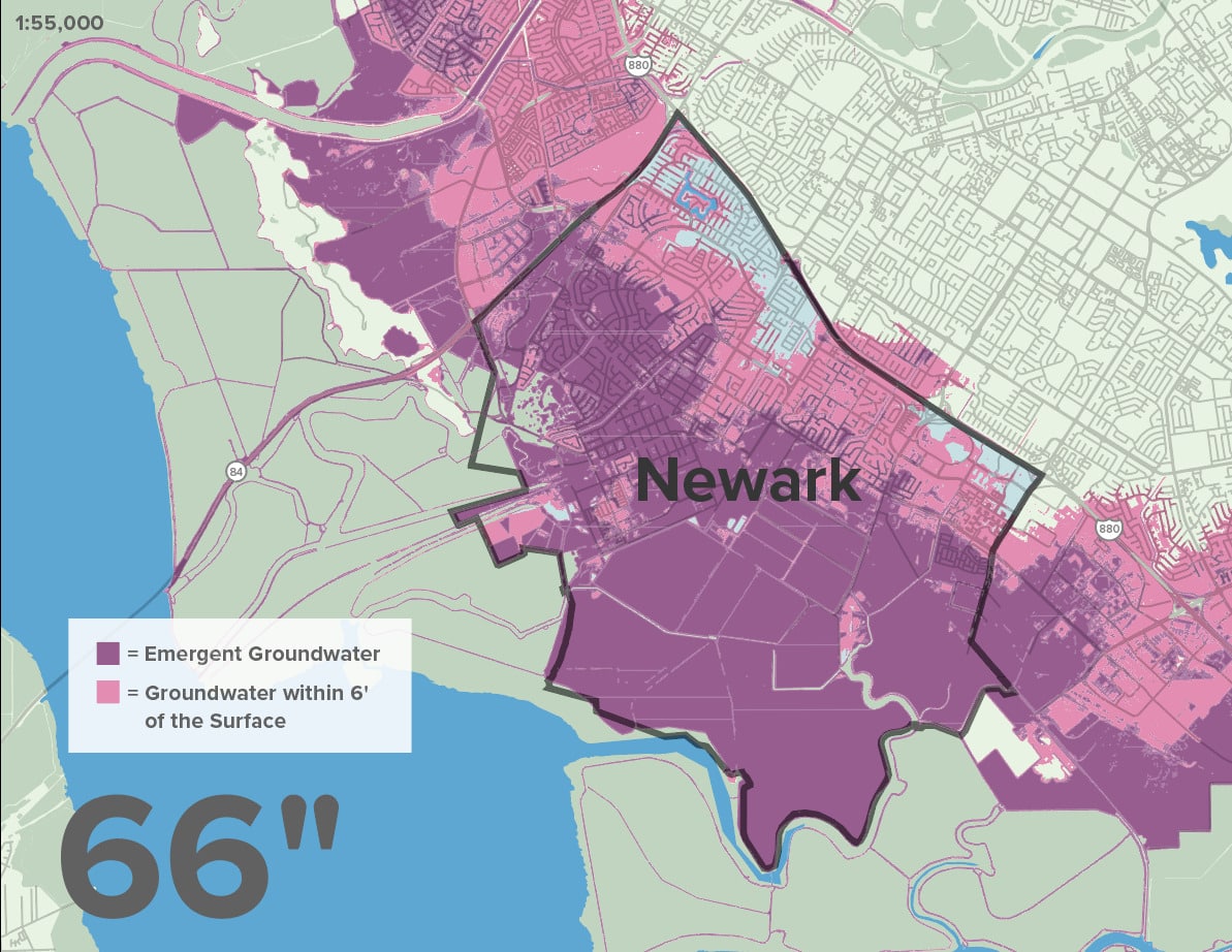
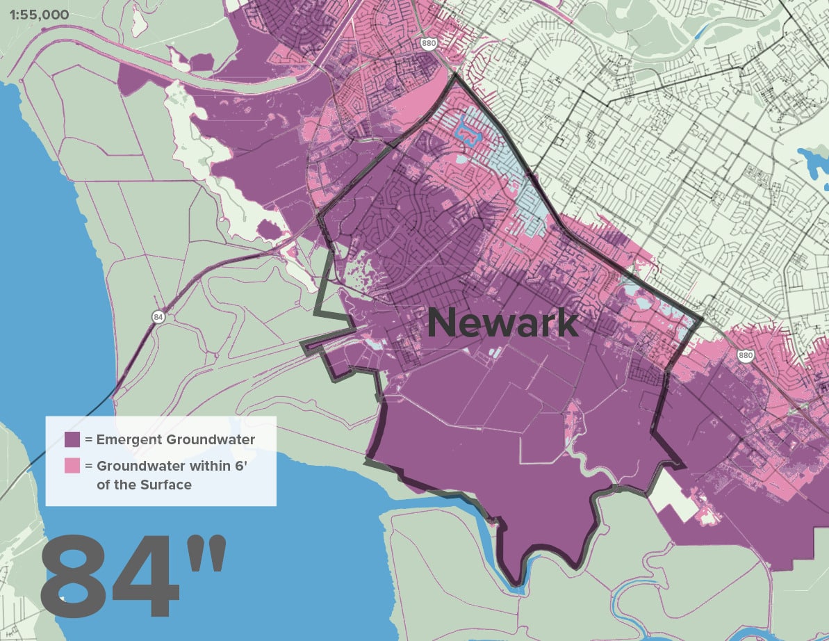
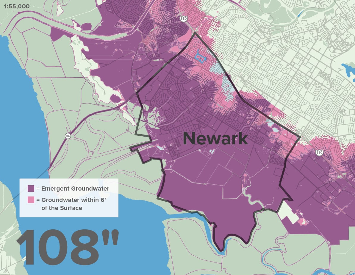
While many are aware of the threats of rising seas, new research has modeled the impact that sea level rise will have on areas with shallow groundwater conditions. Like many developed areas, Newark has a significant amount of infrastructure underground, including gas and electrical lines, telecommunication cables, water and sewer pipes, and building foundations.

As sea level rise pushes groundwater levels up, Newark will experience emergent groundwater conditions, causing water to pool at the surface and cause unstable conditions for buildings and potential corrosion of underground infrastructure. Shallow groundwater conditions present the risk of deploying toxic chemicals and pollutants located in the soil.

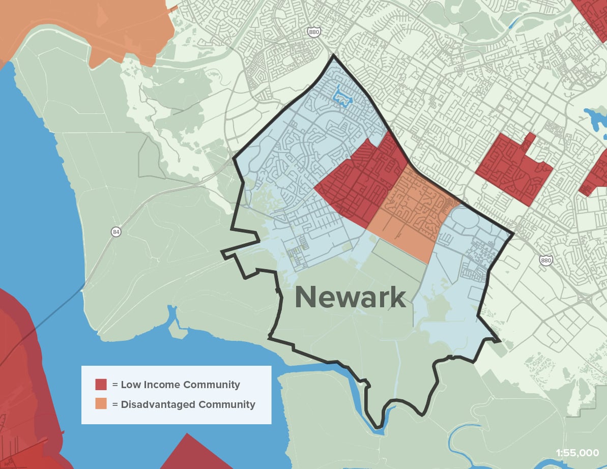
Newark’s shoreline industrial uses near Central Ave and the residential communities located in North Newark, between Jarvis and Mayhews Landing, are likely to be some of the first places to face this new challenge.

Map Citations:

San Francisco Estuary Institute (SFEI). 2022. “Shallow Groundwater Mapping: Alameda County.” Accessed June 1, 2023. https://www.sfei.org/data/shallow-groundwater-mapping.
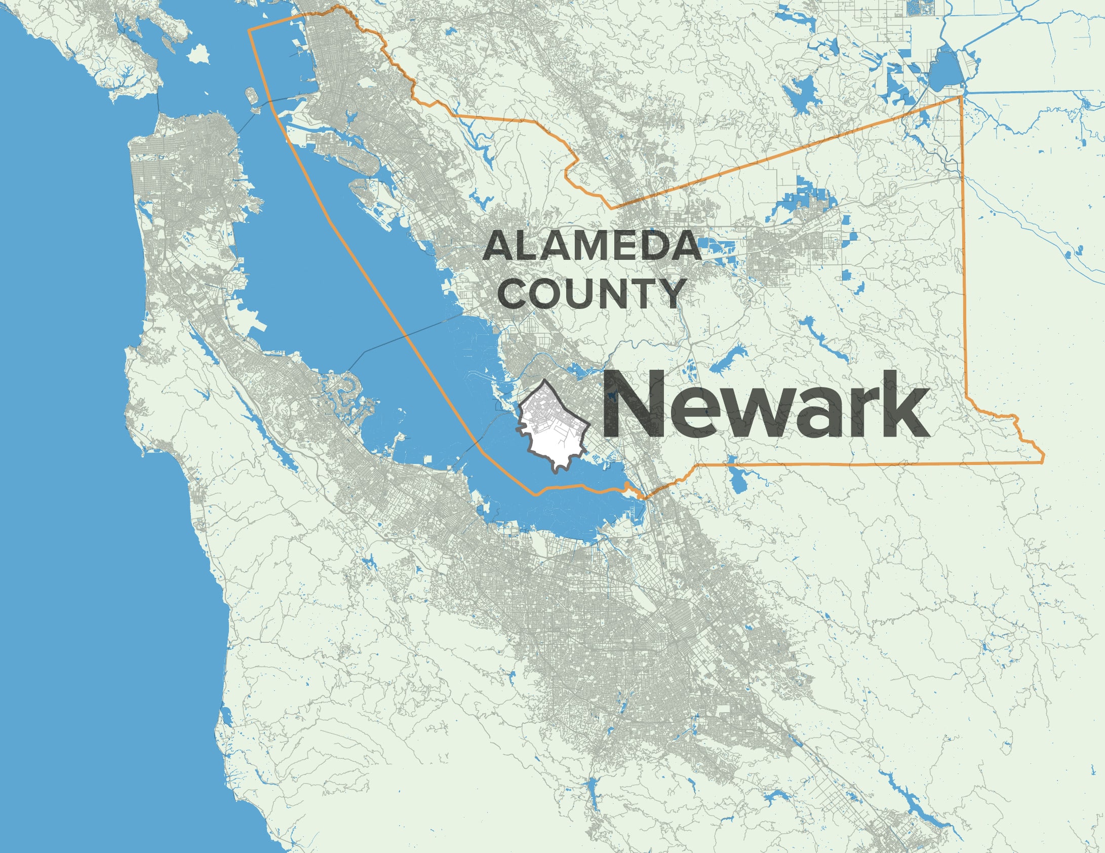
Regional Governance

Newark’s location, nestled between Fremont and Union City on a stretch of shoreline just outside the coastal zone, makes the area jurisdictionally complex when it comes to governing and funding sea level rise adaptation.

Flooding and sea level rise do not respect jurisdictional boundaries. Small cities like Newark may see greater success in adaptation planning when they collaborate with their neighbors on larger regional resilience efforts—bringing in more partners and resources to plan for more effective and efficient projects.

Newark must work with neighboring shoreline communities to plan  comprehensively for long-term adaptation. The Hayward Shoreline Adaptation Plan (link), led by HASPA, has modeled what this effort could accomplish. In collaboration with Union City, Fremont, the Bay Conservation and Development Commission (BCDC), the Alameda Flood Control District, and other partners, Newark can take early action to plan for adaptation that will not only result in risk reduction, but also provide key co-benefits to wetland ecosystems and nearby communities.

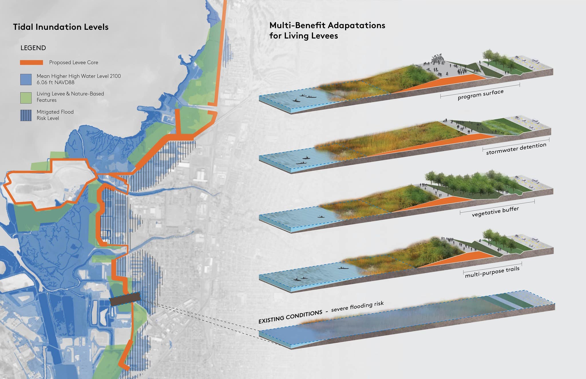
Opportunities for Nature-Based Solutions

Newark’s developed shoreline areas leave little room for Wetland Migration, but restoration of the undeveloped shoreline areas and implementation of nature-based solutions such as the restoration of tidal wetlands, offer near-term solutions to mitigate the impact of flooding.

Recommended Nature-Based Solutions in Newark

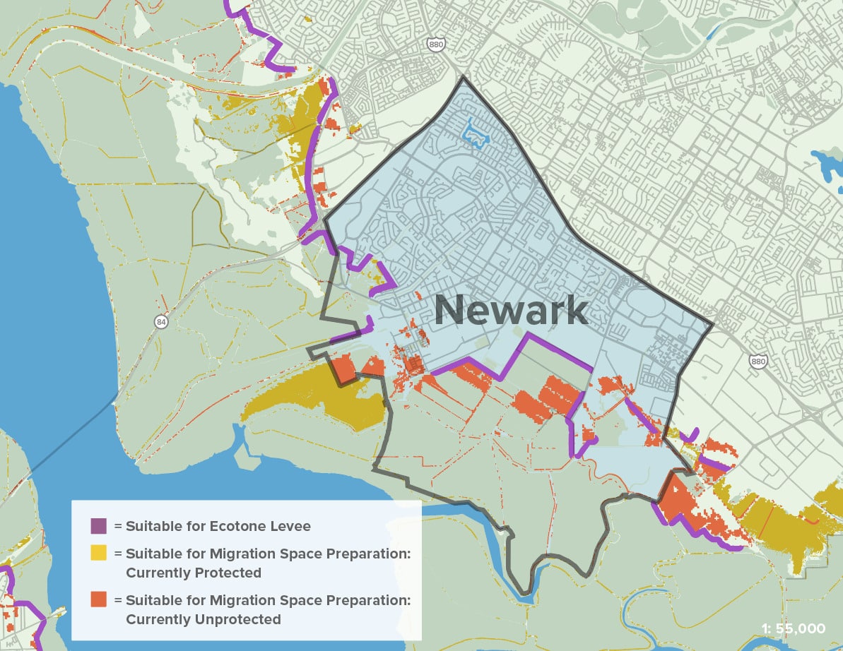
The existing Newark wetlands provide a natural barrier to flooding and storm surge, but as sea levels rise, wetlands will be inundated with water if they are prevented from moving inland. Protection and management of Newark’s wetland areas, identification and preservation of wetland migration spaces (low-lying undeveloped upland areas adjacent to tidal wetlands), are nature-based solutions that have been identified as strategies to build resilience to flooding while simultaneously offering benefits to ecosystems and people.

Supporting wetland migration through nature-based adaptation is not only in Newark’s best interest, but is also important for achieving the Bay Area’s regional equity goals. When one shoreline community develops their shoreline, studies have shown that other communities across the Bay will pay the price through greater flood impacts and pricier adaptation measures (Hummel et al, 2021).

Map Citations:

SFEI Adaptation Atlas: San Francisco Estuary Institute (SFEI). 2019. “San Francisco Bay Shoreline Adaptation Atlas GIS data, Version 3.” Accessed June 1, 2023. http://www.sfei.org/data/adaptation-atlas-data.

Conservation
& Sprawl

As a small city located in the heart of the Bay Area, Newark’s once affordable home prices are now out of reach for many. The lack of multi-family homes and Infill Development, coupled with a lack of protection for Newark’s shoreline, has resulted in Newark losing young families and trying to build the housing they desperately need in wetlands areas rather than climate-SMART infill locations.

Sprawl Risk & Unprotected Lands

The Bay was once a prime dumping ground for construction debris, toxic waste, and all sorts of other unwanted materials. Land use protections and restoration efforts have made the Bay and its shoreline a vital asset for our region, but there are noticeable gaps in those protections, and Newark’s shoreline is a primary example of this—leaving it vulnerable to harmful development.

There are more than 500 acres of historic baylands within Newark’s city limits that are currently undeveloped and unprotected. These lands include Area 4 as well as other parcels, many of which are zoned for housing development. Protecting and managing these lands can mitigate flood risk, minimize the number of people and assets at risk of sea level rise impacts, and support the vitality of bayshore habitats.

Essential and Important Lands for Conservation Goals and Sprawl Risk
1. Conservation Land Network
2. Permanently Protected Lands
3. Sprawl Risk

Spotlight on Area 4

Newark Area 4, a 500-acre historic bayland site, is a remarkable mosaic of wetlands, restorable wetlands, uplands, and wildlife habitat that provide crucial benefits to San Francisco Bay, Newark, and the region. However, Area 4 is at risk of being permanently lost to development.

As historic baylands, almost entirely within a 100-Year FEMA flood zone, Area 4 currently provides an important flood buffer to the City of Newark, and has been identified by climate experts, including the SF Bay Shoreline Adaptation Atlas, as a key opportunity for nature-based adaptation to sea level rise, acting as a sponge to capture flood waters—before they reach our neighborhoods and businesses.

Coastal wetlands have been demonstrated to be one of nature’s most potent sources of “Blue Carbon,” acting quicker and better at trapping organic carbon than forests and delaying carbon increases for longer—providing an important natural tool for combating climate change.

San Francisco Bay advocates and Newark residents have fought vigorously for decades to protect and restore these historic baylands and ensure that they are included in the adjacent SF Bay National Wildlife Refuge. However, the City of Newark and developers have been advancing development plans that would pave over and degrade these restorable wetlands with 469 sprawling housing units, putting new residents in a FEMA flood zone anticipated to be completely inundated by sea level rise.

Housing

The regional housing shortage and Newark’s stagnant supply of affordable housing have driven up housing costs, especially in relation to income, resulting in severe impacts to non-white Newark families in particular.

A lack of housing options coupled with housing prices has resulted in 30.2% of Newark residents being housing cost-burdened. Renters and BIPOC communities are most likely to be cost-burdened, with 41% of Black residents, 46% of Indigenous residents, 47% of Latino residents, and 46% of Multi-racial residents experiencing housing costs that account for over 30% of their income (Newark Housing Element).

As a result of rising housing costs, Newark has experienced a rise in the number of people per unit. When the number of people in one household exceeds the number of bedrooms, it is called overcrowding. Nearly 10% of households in some areas of Newark (Central and Old Town) are experiencing overcrowding and BIPOC households experience this at a disproportionate rate.

As part of Newark’s Housing Element update, the City has planned to accommodate 1,874 new units (40% of which will be affordable) by 2031. Through this planning process, Newark demonstrated that it can meet its housing needs within its existing urban footprint, not requiring development of flood-prone areas.

Social & Health

Newark’s climate impacts will be disproportionately experienced by immigrant communities who face language barriers from being involved in local action and planning.

Social & Economic Vulnerabilities

Newark is a diverse community nestled in the heart of the Bay that has attracted many immigrant communities due to its relative affordability and proximity to nearby job centers.

Three Newark census tracts have been identified as “priority populations” for climate investment due to socioeconomic factors and low-income status in particular.

Social Vulnerability and Sea Level Rise
1. BCDC Community Vulnerability Rank
2. With 108" SLR

Newark is home to large non-white populations with many residents speaking a language other than English. This can make it difficult to get involved in planning meetings, stay up-to-date with local actions, and access vital emergency information if resources and meetings are only available in English.

Low-Income and Disadvantaged Communities


Map Citations:

Bay Conservation and Development Commission (BCDC). 2020. “Community Vulnerability.” Accessed June 20, 2023. https://bcdc.maps.arcgis.com/home/item.html?id=5a14b281c5c9402e81dfdcc29d0a387c

Adapting to Rising Tides: Bay Conservation and Development Commission (BCDC). 2020. “ART Bay Area Sea Level Rise and Shoreline Analysis Maps.” Accessed June 2, 2023. https://explorer.adaptingtorisingtides.org/download.

CalEPA. 2023. “CES 4.0 Priority Populations Investments.” Accessed May 23, 2023. https://gis.carb.arb.ca.gov/portal/apps/experiencebuilder/experience/?id=6b4b15f8c6514733972cabdda3108348&page=About-%26-Resources.

Pollution Burden & Public Health

Newark’s shoreline industrial uses have resulted in legacy toxins that risk being exposed as a result of sea level rise.

CalEnviroscreen Data (using percentile rank for all census tracts in California)
1. Cumulative Environmental Risk
2. Groundwater Threats
3. Hazardous Waste Exposure

There are currently 14 recognized clean-up sites and nearly 30 hazardous waste generators located within Newark’s city limits. Both clean-up sites and hazardous waste facilities are locations with known hazardous material present that can move through the air or water and pose great danger to people living near these sites. As a result of these contaminants, Newark’s groundwater is under great threat, ranking in the 97th percentile for groundwater threats amongst all California census tracts.

Map Citations:

California Office of Environmental Health Hazard Assessment (OEHHA). 2021. “CalEnviroScreen 4.0 GDB file.” Accessed June 16, 2023. https://oehha.ca.gov/calenviroscreen/report/calenviroscreen-40.

Community Partners

Other Key Partners
& Leaders

Opportunities for Resilience

The following goals and recommended next steps have been informed by conversations and feedback from a variety of local stakeholders as well as a thorough review of past and ongoing documents and studies, with support from data analyses and land-use and planning expertise.

GOAL

Establish a strong network of advocates in Newark and the Tri-City area to support protection and management of the Newark area shoreline and citywide flood risks.

NEXT STEPS

Convene a working group or coalition of relevant agencies, including public, nonprofit, and community partners to discuss options for shoreline resilience and flood risk management. 

Host guided outings, use social media, and develop creative communication strategies to engage more people in this work, especially youth audiences.

Foster climate champions both within and outside of local government, as they are vital to advancing planning and implementation—especially when considering Newark’s limited resources and capacity.

GOAL

Protect, restore, and manage the Newark shoreline and wetland ecosystems.

NEXT STEPS

Connect the protected shoreline in southern Alameda County and plan for long-term vitality through the creation of an adaptation strategy.

Identify agencies, tools, and/or mechanisms for managing the shoreline across jurisdictions and funding for ongoing adaptation needs.

GOAL

Adapt to inland flooding that results from shallow groundwater and sea level rise, and share strategies and success stories as a case study.

STRATEGIES

Engage local residents, City staff, and elected officials to build awareness around the threat of shallow groundwater in relation to sea level rise.

Work with subject matter experts and local staff to identify mitigation strategies that are effective and feasible.

Barriers to Action

  1. Newark can act to better protect and manage its wetlands, yet the region’s wetland and shoreline resources are highly dependent on the actions of neighboring cities. Currently, there is a lack of regional coordination along the southern Alameda shoreline, making comprehensive and long-term planning difficult to execute.
  2. Most southern Alameda residents and policymakers are largely unaware of the threat that shallow groundwater poses by exposing inland communities to extreme flooding, infrastructure loss, and public health risks. The lack of knowledge about shallow groundwater risks is currently a barrier to strategic mitigation, but is also a prime opportunity to expand awareness through public education and strategic advocacy.
  3. Newark is a small city with many competing needs and priorities—including economic and education improvements—making it difficult to prioritize long-term climate resilience.

Newark Actions & Updates

Mowry Village Proposal

Greenbelt Alliance is working with the Citizens Committee to Complete the Refuge and other Newark advocates to oppose the development of single family homes on a flood-prone parcel zoned for park uses.

VOICE YOUR SUPPORT
Plant Trees with Urban Forest Friends

Join UFF on November 18th at Byington Park for community tree-planting days!

LEARN MORE AND SIGN UP
The Newark Shoreline Area is a FEMA Community Disaster Resilience Zone

FEMA has identified the Southern Alameda Shoreline and wetland areas as some of the most at-risk and in-need areas in the country. This designation prioritizes the area for financial and technical assistance to reduce the impact of climate change and strengthen community resilience.

FIND OUT MORE HERE
Newark featured in Bay Nature

Read more about the Newark wetlands’ regional significance for meeting our climate goals in Bay Nature.

READ MORE
Scroll to Top